ARTICLE

Using Map in a Pocket PC Application

Posted by Shail Srivastav Articles | Compact Framework April 19, 2004
GPS enabled applications are a good example of using a Pocket PC to locate a Pocket PC user. This attached application is a location based Pocket PC application developed using .NET compact framework.
Reader Level:
Download Files:
 

GPS enabled applications are a good example of using a Pocket PC to locate a Pocket PC user. This attached application is a location based Pocket PC application developed using .NET compact framework.

The Panel control is also an important control in Pocket PC application due to the limited area of display available in a Pocket PC and hence its a good idea to move information into different areas.

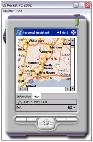
In the attached application, I use two panel controls - first panel control is to display the information and second is for the map.

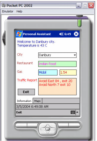
Here I want to show a GPS enabled Pocket PC application, which shows the map where you are and also nearby business information. Which are following in this case.

1. City, where you are right now.
2. Gas
3. Traffic Report
4. Restaurant

Images:

Login to add your contents and source code to this article
post comment
     

can i know what the extention of the map used in this applicationKand what i can do if i use .mxd map(build in ArcGIS)

Posted by eminel el Mar 12, 2008

can someone tell on how to work this program run without error...."exemption...."

Posted by ming ching Mar 10, 2008

Can you recommend some pocket pc application in c# for college project

Posted by Rupali Thigale Mar 01, 2007
COMMENT USING
PREMIUM SPONSORS
DynamicPDF™ product line allows you to dynamically generate PDF documents, merge PDF documents and add new content to existing PDF documents from within your applications.
Join a Chapter
SPONSORED BY
  • PDF reports have never been easier to create. With our included WYSIWYG Designer, you can layout your reports, set up your data source and let DynamicPDF ReportWriter do the rest.
Get Career Advice from Experts