

Introduction:
Geocoder.us offers a free (for non-commercial use) web service that may be used
to geocode physical addresses. The details of the service and usage terms may be
located at:http://geocoder.us/.
In general, the Geocoding service is based upon the use of Tiger/Line data
gathered by the US Census bureau. Geocoding is defined as the process of
estimating the latitude and longitude of a physical address. Naturally the
service is based upon physical addresses so its use is limited to tagging
physical addresses with a lat/long. Also, since this is based upon US Census
Bureau data, only US addresses can be geocoded using the service and the
accuracy of the data is largely dependent upon the quality of the Census Bureau
data.
This article will demonstrate the basics of submitting an address to the
service, recovering and displaying the geocoded result, and will also
demonstrate a simple approach to displaying the location by mapping it with
Yahoo! maps.
The service can be used to obtain and store latitude and longitude on all of the
addresses contained in some sort of contact database or asset location database,
or might be useful for storing waypoints in a GPS navigation device.
The demonstration application will evoke the web service to find the coordinates
for a physical address and will display the best result along with any other
addresses that match the search criteria. In Figure 1, note that the search
term, "100 Peachtree, Atlanta, GA" was sent to the service; the best result is
displayed in the "Best Match" group and all matches are displayed in the "All
Possible Matches" group box. Since "Peachtree" is a very common name for a
street in Atlanta where it is apparently the civic pastime to name streets
"Peachtree", the data grid view control contained in the "All Possible Matches"
group is pretty full.
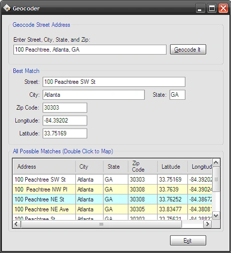
Figure 1: The demonstration application
running
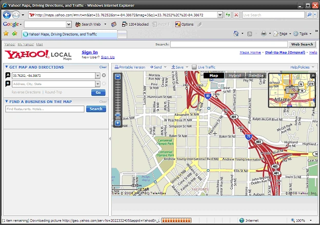
Figure 2: Displaying the coordinates in Yahoo
Maps
Getting Started:
In order to get started, unzip the included project and open the solution in the
Visual Studio 2005 environment. In the solution explorer, you should note these
files (Figure 3) along with a web reference pointing to http://rpc.geocoder.us/dist/eg/clients/GeoCoder.wsdl:
Figure 3: Solution Explorer
The Main Form (Form1.vb).
The main form is the only form contained in the application; all of the
application specific code required to access the service, return the results of
an address search, and to display those results as text or as a map are included
in this class.
The code is pretty simple, if you'd care to open the code view up in the IDE you
will see that the code file begins as follows:
Public Class Form1
Public Class Form1
''' <summary>
'''
Default Constructor
''' </summary>
''' <remarks></remarks>
Public Sub New()
'
This call is required by the Windows Form Designer.
InitializeComponent()
' Add any initialization after the InitializeComponent() call.
End Sub
The next section of the code is used to parse the results returned from the web
service and to display the results to the user in the "Best Match" and "All
Possible Matches" groups. The code is annotated to describe what each part of
the code does.
''' <summary>
''' Use the geocoder.us web service
''' to geocode and address; display both
''' the best matching address along
''' with a collection of all addresses
''' meeting the search criteria
''' </summary>
''' <param name="sender"></param>
''' <param name="e"></param>
''' <remarks></remarks>
Private Sub GetLatLong(ByVal sender As Object, _ByVal e Asus.geocoder.rpc.geocode_addressCompletedEventArgs)
Try
' the address is broken up into parts so
' reassemble them into a street address using
' only the parts that have been populated
' by the service
' start with the street number
txtStreet.Text = e.Result(0).number.ToString() + " "
' add the prefix (e.g., N, SE, etc.)
If e.Result(0).prefix.ToString() <> String.Empty Then
txtStreet.Text += e.Result(0).prefix.ToString() + " "
End If
' add the street name
If e.Result(0).street.ToString() <> String.Empty Then
txtStreet.Text += e.Result(0).street.ToString() + " "
End If
' add the suffix (if any)
If e.Result(0).suffix.ToString() <> String.Empty Then
txtStreet.Text += e.Result(0).suffix.ToString() + " "
End If
'add the street type (e.g., ST, CT, RD, PKWY, etc.)
If e.Result(0).type.ToString() <> String.Empty Then
txtStreet.Text += e.Result(0).type.ToString()
End If
' add the city, state, and zip
txtCity.Text = e.Result(0).city.ToString()
txtState.Text = e.Result(0).state.ToString()
txtZip.Text = e.Result(0).zip.ToString()
' display the latitude and longitude
txtLatitude.Text = e.Result(0).lat.ToString()
txtLongitude.Text = e.Result(0).long.ToString()
' create a datatable to hold any additional
' possible address matches
Dim dt As New DataTable()
' define all of the columns and add them
' to the data table
Dim dcAddress As New DataColumn()
dcAddress.DataType = System.Type.GetType("System.String")
dcAddress.ColumnName = "Address"
dcAddress.Caption = "Address"
dt.Columns.Add(dcAddress)
Dim dcCity As New DataColumn()
dcCity.DataType = System.Type.GetType("System.String")
dcCity.ColumnName = "City"
dcCity.Caption = "City"
dt.Columns.Add(dcCity)
Dim dcState As New DataColumn()
dcState.DataType = System.Type.GetType("System.String")
dcState.ColumnName = "State"
dcState.Caption = "State"
dt.Columns.Add(dcState)
Dim dcZip As New DataColumn()
dcZip.DataType = System.Type.GetType("System.String")
dcZip.ColumnName = "Zip Code"
dcZip.Caption = "Zip"
dt.Columns.Add(dcZip)
Dim dcLat As New DataColumn()
dcLat.DataType = System.Type.GetType("System.String")
dcLat.ColumnName = "Latitude"
dcLat.Caption = "Lat"
dt.Columns.Add(dcLat)
Dim dcLong As New DataColumn()
dcLong.DataType = System.Type.GetType("System.String")
dcLong.ColumnName = "Longitude"
dcLong.Caption = "Lon"
dt.Columns.Add(dcLong)
' create a row
Dim row As DataRow
' loop through all of the results and
' add each row to the data table for
' display in the All Possible Matches
' datagridview control
Dim i As Int32
For i = 0 To e.Result.Length - 1
' create a new row
row = dt.NewRow()
' build a street address
Dim addr As String = e.Result(i).number.ToString() & " "
If e.Result(i).prefix.ToString() <> String.Empty Then
addr += e.Result(0).prefix.ToString() + " "
End If
If e.Result(i).street.ToString() <> String.Empty Then
addr += e.Result(i).street.ToString() + " "
End If
If e.Result(i).suffix.ToString() <> String.Empty Then
addr += e.Result(i).suffix.ToString() + " "
End If
If e.Result(i).type.ToString() <> String.Empty Then
addr += e.Result(i).type.ToString()
End If
' set the street address
row("Address") = addr
' set the city, state, and zip code
row("City") = e.Result(i).city.ToString()
row("State") = e.Result(i).state.ToString()
row("Zip Code") = e.Result(i).zip.ToString()
' set the latitude and longitude
row("Latitude") = e.Result(i).lat.ToString()
row("Longitude") = e.Result(i).long.ToString()
' add the new row to the table
dt.Rows.Add(row)
Next
' configure and bind the grid to the table
dgvMatches.DataSource = dt
dgvMatches.SelectionMode = _
DataGridViewSelectionMode.FullRowSelect
dgvMatches.AutoSizeRowsMode = _
DataGridViewAutoSizeRowsMode.AllCells
dgvMatches.RowHeadersVisible = False
dgvMatches.ScrollBars = ScrollBars.Both
dgvMatches.Refresh()
Catch ex As Exception
MessageBox.Show(ex.Message, "Address")
End Try
End Sub
Next up is the button click event handler used to evoke the Geocoding web
service; the code is annotated to describe what is going on within the event
handler.
''' <summary>
''' Click event handler used to evoke
''' the web service and to geocode the
''' physical address passed to that
''' service
''' </summary>
''' <param name="sender"></param>
''' <param name="e"></param>
''' <remarks></remarks>
Private Sub btnGeocode_Click(ByVal sender As System.Object, _ByVal e As System.EventArgs)Handles btnGeocode.Click
' make sure there is an address
' to geocode
If txtSearchAddress.Text = String.Empty Then
MessageBox.Show("Invalid search address.", "Error")
Return
End If
Try
' instance the geocoder service
Dim gcAddress As New us.geocoder.rpc.GeoCode_Service()
' the event handler for completion of the
' geocoding does the work of displaying the
' results the site offers alternative
' methods for viewing the geocoding results
AddHandler gcAddress.geocode_addressCompleted, _AddressOf GetLatLong
' call the asynchronous version of the geocoder
gcAddress.geocode_addressAsync(txtSearchAddress.Text)
' dispose of the service instance
gcAddress.Dispose()
Catch ex As Exception
MessageBox.Show(ex.Message, "Geocoding Error")
End Try
End Sub
The Exit button event handler is described in the next section; this code merely
terminates the application.
''' <summary>
''' Exit the Application
''' </summary>
''' <param name="sender"></param>
''' <param name="e"></param>
''' <remarks></remarks>
Private Sub btnExit_Click(ByVal sender As System.Object, _ByVal e As System.EventArgs)Handles btnExit.Click
Application.Exit()
End Sub
The last bit of
code contained in the application is used open the Geocoded coordinates returned
from the service into a running instance of Yahoo Maps. The approach here is
simply to format a query string using the values returned from the service.
''' <summary>
''' Open a Yahoo! Map pointing at the location as
''' plotting using the latitude and longitude
''' recovered from the service.
''' Note: There will likely be some error on
''' the position as this tool returns an
''' estimated lat/lon with no guarantee of
''' accuracy
''' </summary>
''' <param name="sender"></param>
''' <param name="e"></param>
''' <remarks></remarks>
Private Sub dgvMatches_DoubleClick(ByVal sender As System.Object, _ByVal e AsSystem.EventArgs) Handles dgvMatches.DoubleClick
' map the location on a double click
' get the lat and long from the selected row
Dim strLat As String = _
dgvMatches.SelectedRows(0).Cells(4).Value.ToString()
Dim strLon As String = _
dgvMatches.SelectedRows(0).Cells(5).Value.ToString()
' launch Internet Explorer and fill in the lat and
' long values url's argument list
System.Diagnostics.Process.Start("iexplore.exe", _"http://maps.yahoo.com/#mvt=m&lat=" + strLat + _"&lon=" + strLon + "&mag=3&q1=" + strLat + _"%2C%20" + strLon)
End Sub
Summary.
This application was provided as an example of how one might take advantage of
the Geocoder.us Address Geocoding service. This service is free for
non-commercial use. If one were required to geocode a collection of addresses
yet lacked access to some of the available third party tools (such as the ESRI
product line), this service could be invaluable. The service mentioned in this
article is also capable of Geocoding road intersections which could also be very
useful.
Join the conversation! Your thoughts help the community grow.